Polygons to cells: GDAL’s rasterizer
Zonal statistics, masks and cutlines all start by asking which cells of a grid a polygon gets. There are three common answers: the cells whose centre is inside, every cell the polygon touches, or every cell weighted by how much of it is covered. This page explains how GDAL’s rasterizer gives the first two, how wxylib ports it without making a raster, and how the cells are compared with GDAL’s.
The code is crates/wxy-warp/src/rasterize.rs and zonal.rs in wxylib/core. The GDAL code it ports is alg/llrasterize.cpp and the ring handling in alg/gdalrasterize.cpp (GDAL 3.12). For how wxy zonal uses the cells, with timings against GDAL and exactextract, see the zonal statistics example.
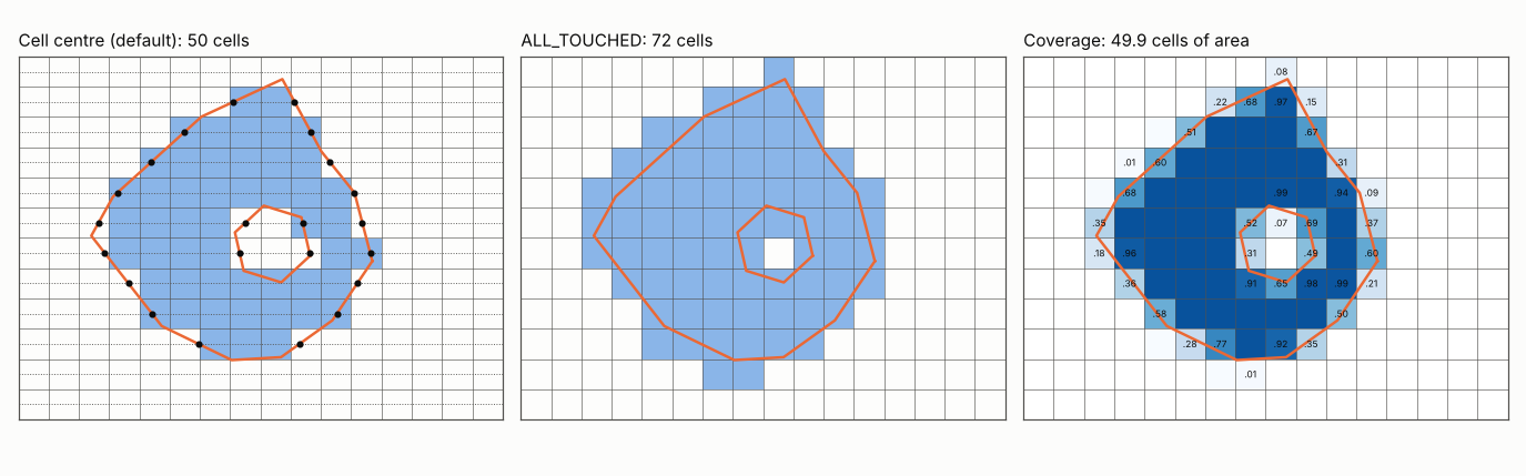
Cell centres: the scanline fill
GDALdllImageFilledPolygon walks the grid row by row. For each row it draws a horizontal line through the row’s cell centres (row + 0.5) and finds where every edge of every ring crosses it (the dots in the figure). An edge counts when the line is at or above its lower end and strictly below its upper end, so a vertex exactly on the line is counted once, not twice. Each crossing is rounded to a cell boundary with floor(x + 0.5), the crossings are sorted, and the cells between the first and second, third and fourth, and so on are burned.
So a cell is in when its centre is inside the polygon, with ties broken the same way every time. Holes and multi-part polygons need no special case: a hole’s edges add crossings, and the pairing leaves its cells out. Horizontal edges cross no scanline and are handled apart.
ALL_TOUCHED: walking the edges
With ALL_TOUCHED GDAL burns the scanline fill and, in addition, every cell each ring passes through (GDALdllImageLineAllTouched). It walks each edge from left to right, cell to cell, stepping to the next column boundary or the next row boundary, whichever the edge reaches first. An edge lying exactly on a cell boundary (to within 1e-4 of a cell) touches neither side, so a rectangle drawn on cell boundaries burns the cells inside it and no more. Nudges of 1e-9 keep the walk moving when it lands exactly on a corner.
Before the burn
Two things happen to the polygon before any cell is burned, and both change the answer:
- Rings are wound clockwise.
gdal_rasterizerewinds each ring clockwise in its own CRS (OGR’sisClockwise), so the edges reach the burn in a fixed order whichever way the input was wound. - Vertices are moved one by one. A polygon in another CRS is reprojected vertex by vertex, without adding points along the edges. A long edge that is straight in lon/lat stays straight in the grid’s CRS, where the true line of constant latitude would curve. To follow the curve, densify the polygon before burning it.
Coverage fractions
GDAL’s rasterizer has no third rule. wxylib’s --coverage takes the exact fraction of each cell the polygon covers, as exactextract does, from controlledburn: whole interior cells, with a fraction for every cell an edge crosses. Each ring is burned on its own and holes are subtracted. The fractions sum to the polygon’s area in cells, and every cell the centre rule burns is among them.
How wxylib does it
GDAL burns into a raster the size of the grid. wxylib keeps the same arithmetic but records each burn as a row span (row, first column, last column) and never makes the raster. Its memory is the spans, roughly the polygon’s perimeter in cells plus one span per row. wxy zonal groups the spans by the source chunks they cross and reads each chunk once (see the example).
| GDAL | wxylib |
|---|---|
GDALdllImageFilledPolygon |
filled_polygon (rasterize.rs) |
GDALdllImageLineAllTouched |
line_all_touched (rasterize.rs) |
OGRLineString::isClockwise |
is_clockwise (rasterize.rs) |
rings wound and vertices moved (gdalrasterize.cpp) |
Burner::gdal (zonal.rs) |
| cells for each polygon alone | polygon_cells (zonal.rs) |
| (exactextract) coverage | polygon_coverage, through controlledburn (zonal.rs) |
How the match is tested
wxylib/fixtures polygons/, made by scripts/make_polygon_fixtures.py: 12 random star-shaped polygons over each of five GeoTIFF fixtures, some with holes and some wound the other way, given both in EPSG:4326 and in the file’s own CRS (nine cases). For each polygon alone, the cells GDAL burns (rasterio.features.rasterize, which calls GDALRasterizeGeometries), by centre and with ALL_TOUCHED.
cargo test -p wxy-warp --test polygons requires every polygon’s cells, by both rules, to be exactly GDAL’s: no cell extra and none missing, for all 108 polygons. For coverage it checks that every cell the centre rule burns is covered, every fraction is in (0, 1], and a polygon inside the grid covers its own area to within 1e-4 of a cell.
The figure is made by rasterize-figure.py, with GDAL’s rasterizer for the first two panels and shapely for the fractions.