Values at points: gdallocationinfo and InterpolateAtPoint
Reading a raster at a list of points looks simpler than a warp, and is, but it has its own rules: which cell a point falls in, what happens at the edge and around nodata, and how the interpolated reads differ from a warp’s kernels. This page explains GDAL’s two point reads, how wxylib plans them so that each chunk is read once, and how the values are compared.
The code is crates/wxy-warp/src/extract.rs in wxylib/core and the wxy points command. The GDAL behaviour it ports is gdallocationinfo (apps) and GDALRasterBand::InterpolateAtPoint (gcore/gdal_interpolateatpoint.cpp, GDAL 3.10 and later).
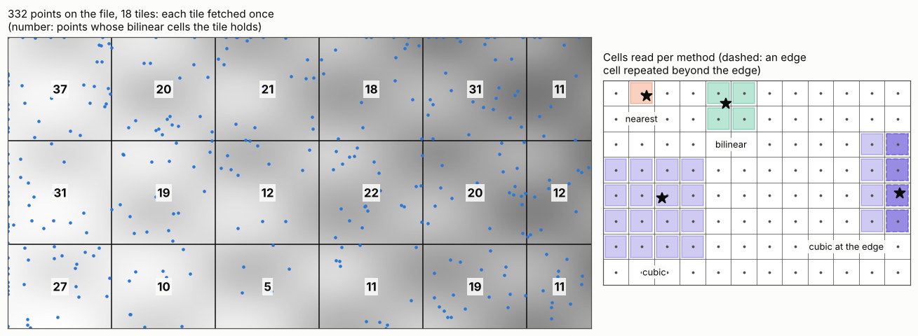
Where a point falls
GDAL finds a point’s position in two steps: transform it from its own CRS to the raster’s, then apply the inverse geotransform, giving a fractional pixel and line (0 at the outer edge of the first cell). For a curvilinear source the second step is the inverse of the geolocation arrays instead (see curvilinear grids). A single point is transformed exactly, without the warper’s approximate transformer.
Nearest: the cell it falls in
gdallocationinfo reads the cell the position falls in: the floor of pixel and line. A point is on the raster when 0 <= pixel < width and 0 <= line < height. The value is returned in the raster’s own type, nodata included (it is up to the caller to compare with the nodata value).
Interpolated: InterpolateAtPoint
InterpolateAtPoint works on cell centres: it subtracts half a cell from the position, and puts its kernel on the 2 x 2 (bilinear) or 4 x 4 (cubic, cubic spline) cell centres around the point. Its rules differ from the warp kernels’ (see resampling kernels) in ways that change the numbers:
- Edges repeat. Kernel cells beyond the raster’s edge take the value of the nearest edge cell. The warper instead drops them and renormalises. A point is on the raster up to and including its far edge (
pixel <= width). - Nodata. Bilinear gives no value at all if any of its four cells is nodata. Cubic and cubic spline leave nodata cells out of the weights and renormalise over the rest, giving no value only if nothing is left.
- No stretch. There is no target resolution, so the kernel is always 1:1.
- Doubles out. The result is a 64-bit float, not rounded to the raster’s type.
- Small rasters downgrade the method: cubic becomes bilinear below 4 x 4 cells, bilinear becomes nearest below 2 x 2.
Cubic is Catmull-Rom, as in the warper; cubic spline is the cubic B-spline, which smooths rather than interpolates (it does not pass through the cell values).
How wxylib plans the reads
GDAL reads points one at a time through its block cache. wxylib plans them first (plan_points):
- transform all points to source positions, as above;
- work out which cells each point’s kernel needs, with edge cells clamped (or wrapped, below);
- group the points by the chunks (tiles) that hold those cells. A point whose kernel crosses a chunk boundary is in each group.
Then each chunk is fetched and decoded once, however many points need it, and every slice of any leading dimensions (time, depth, band) is read at the same positions. In the figure, 332 points on the world fixture touch all 18 of its tiles, so 18 reads serve them all.
One deliberate difference: for a lon/lat source spanning 360 degrees, wxylib wraps a point’s longitude into the source, and lets a kernel at the left or right edge take cells from the other side rather than repeat the edge. --no-wrap (CLI) or wrap_globe: false gives GDAL’s behaviour, where such a point is off the raster.
| GDAL | wxylib (extract.rs) |
|---|---|
point to pixel and line (gdallocationinfo) |
plan_points (through the warp transformer, exact) |
| pixel and line given directly | plan_pixels |
| on-raster tests, method downgrade | plan_from |
InterpolateAtPoint (bilinear, cubic, cubic spline) |
interpolate |
CubicKernel, CubicSplineKernel |
cubic, cubic_spline |
ARE_REAL_EQUAL (nodata comparison) |
are_real_equal |
wxy points reads x,y lines on standard input and writes CSV in long form: x,y, the index of each leading dimension, and value, one row per point and slice.
How the match is tested
wxylib/fixtures points/, made by scripts/make_point_fixtures.py: 400 random points over each of five GeoTIFF fixtures (byte, uint16, int16 and float32 with nodata; one to three bands), given both in EPSG:4326 and in the file’s own CRS, so nine cases. The nearest values are what gdallocationinfo reads. The interpolated values come from GDAL’s own GDALRasterInterpolateAtGeolocation, called through ctypes in the GDAL that rasterio bundles, along with GDAL’s own pixel and line for each point.
cargo test -p wxy-warp --test points checks, for every case:
- nearest: which points are on the raster, and every value, identical to GDAL’s;
- interpolated: at GDAL’s own pixel and line, every bilinear, cubic and cubic spline value identical (no value exactly where GDAL has none); from the points themselves, positions within 1e-8 pixels of GDAL’s, the difference between the pure-Rust proj4rs and PROJ;
- planning: no chunk fetched twice, and exactly the chunks the plan lists.
The figure is made by points-figure.py from the world fixture and its point case.