A curvilinear grid with a time axis, to a polar map
The question: “I have a NetCDF file on a curvilinear grid (2D latitude and longitude), with several time steps. How do I get it onto a regular map grid, all time steps at once?” Asked on Scientific Python (unanswered), as rioxarray #47, and in R as stars #513 and stars #618, where the warp leaves gaps and objects with several time slices fail, so people warp one slice at a time.
What wxylib does: wxy-zarr finds the 2D lon and lat arrays the way CF says to (the coordinates attribute, then standard_name, units or the usual names). wxy-warp places the cells with a port of GDAL’s geolocation-array transformer (see the explainer), and streams every slice of the leading dimensions under one plan: the backmap is built once, and each source chunk is fetched once.
The run
run.py writes a small xarray-style Zarr store: data(time, y, x) with 2D lon(y, x) and lat(y, x), a ring of 50 x 180 cells round Antarctica whose longitudes cross the antimeridian, and a pattern that rotates 40 degrees a day for three days. Then:
wxy warp curvilinear.zarr warped.zarr --source-array /data \
  --crs EPSG:3031 --extent -3000000 -3000000 3000000 3000000 \
  --size 400 400 -r bilinear
All three days are warped in one command, and the output store keeps the time axis:
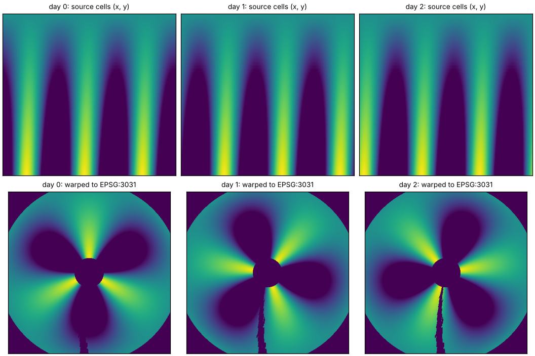
Add --dry-run and the same command prints the plan instead of reading anything. Here it is one chunk of 108 KB (the whole small store) and the target grid it lands on. For a large store, that JSON shows which chunks a warp will fetch and how many bytes, before it runs.
What to notice
- The hole at the pole is real: the grid stops at 85S.
- The ragged wedge below the pole is where the ring closes, between the last column (near 180E) and the first (near 180W). The geolocation transformer treats the grid as a sheet with two edges, so target cells in that seam find no source cell to interpolate from. GDAL’s warper does the same thing, and wxylib matches it value for value in the fixtures. A wrap-aware option (joining the first and last columns) would close it. That is a candidate feature that would go beyond GDAL parity.
Limits
- The input has to be Zarr. A netCDF file can be read through a byte-reference table today (see the OISST walk-through), but not opened directly. That is the most common blocker between the forum questions above and this command.
- 1D CF bounds are not read yet; 2D bounds are (
--bounds). - The R and Python packages do not run this yet: they warp in-memory arrays only.
- Values at points on the same store need no warp at all:
echo 150,-70 | wxy points curvilinear.zarrgives one value per day.